Early 2019 Day Hikes
First 2019 day hike
The first day hikes of 2019 were not overly exciting but they did get me on the trail and in the woods, The first was on the trails on the Mohawk River State park (near where I live). I took no pictures because I had the dog with me and there wasn't anything new to take a picture of (I posted pictures from previous walks on those trails previously). Some parts of the trails were wet from the recent large rainfall but were otherwise passable, I saw only a couple of people on the trails themselves riding mountain bikes (the main users of the trails in the park). The one downside to these trails is the inconsistent blazing used and lack of of any signage at intersections. After managing to put a number of miles on the trails and enjoying the spring weather I returned to my vehicle. A decent first hike for the year.
Second 2019 day hike
The second day hike was in PA on a number of connected trails near the Susquehannock Trail but not intersecting it. The trails involved were the Beech Hollow trail, the West Branch trail, the Captain Shelton trail and an ATV trail (unnamed). These are all on the DCNR Billy Lewis trail map (which is how I learned of them). I normally don't say much about the trailhead, but it seemed unusual to me that the trailhead parking which is geared towards ATVs was mostly taken up by people in their RVs sitting around while their ATVs were also just sitting there. This camping is allowed but I would have guessed they would be more actively using their ATVs. Anyway, I left the parking area to the start of the Beech Hollow trail (the Captain Shelton trail also at a terminus here (discussed later). The Beech Hollow trail starts to gently descend form here.
 |
| Start of the Beech Hollow trail |
 |
| Junction with the West Branch Trail |
I turned left (west at the intersection). This trail was not very wide and is obviously not necessarily intended for cross-country skiing, I could hear an ATV not too far away (on the ATV trail on the other side of the water way), not surprising given the ATV trails and ATVers I saw earlier. Along the trail there was the occasional sign of beaver activity as seen below.
 |
| Signs of beaver activity |
 |
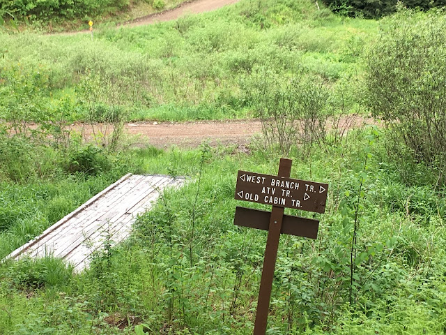
| Junction with Old Cabin trail |
However, a short walk up the Old Cabin trail revealed a lack of blazes or obvious footway. So, I decided to continue on the West Branch trail which still had both despite not being on the map. I continued west (pun intended) on the West Branch trail although the blazes were fewer between and the footway was less obvious, but it was still discernible so I knew I was on the right path. According to the map, it was possible to reach an ATV trail to take me back to my vehicle at the Captain Sheldon Connector trail. After some time I reached the turn and according to the map, the West Branch trail looked like it would continue further west to a road and parking area. But I stopped for lunch before heading uphill. This trail was only occasionally blazed and the footway was sometimes not discernible, but I followed the obvious route using the 'where would a trail be if I made the trail' logic. I did have a backup plan if I lost the trail, continue uphill until I reached the ATV trail, but I did not need it.
 |
| Junction of Connector trail and West Branch trail |
 |
| Orange newt on the connector trail |
Although the trail was faint towards
the top, I did find the ATV trail (hard to miss actually). And at the
intersection the below sign marked the upper end of the trail. I did
wonder at how someone might follow the trail down from here.
 |
| Junction of connector trail and ATV trail |
Once on the ATV trail I headed east, walking along the edge of the trail/road. For awhile I had the trail to myself but eventually a few ATVs passed me (they waved) filled with families. Although the noise was bothersome I kept walking until some time later I found the connection with the Captain Shelton trail (the target of the connector trail obviously). This trail follows an old gas pipeline right-of-way, as seen below.
 |
| Junction with Captain Shelton trail |
At first this trail was overgrown and
brushy but eventually it became clear. It started raining again and
while it rained the trail went trough some close growth and through
more woods before eventually reaching my starting point, seen below.
 |
| End/Start of Captain Shelton trail |
Despite the rain and faint trails in some places this was a good hike having taken me over new trails (to me) without a long drive to the trailhead.

Comments